
Colorado, Kansas, Missouri, and Oklahoma Face Sunday Hail Threat With Hen-Egg-Size Stones Capable of Denting Cars
DENVER, COLORADO — A Day 2 severe weather outlook is warning of large, damaging hail across a wide stretch of the Central Plains and Midwest for Sunday, June 21, 2026. The forecast, updated Saturday afternoon, highlights a corridor stretching from eastern Colorado through Kansas, Missouri, and into parts of Oklahoma and southern Illinois.
Hen-Egg-Size Hail Most Likely Near Akron, Burlington, and Cheyenne Wells
The most likely spot for hen-egg-size hail is centered around Akron, Burlington, and Cheyenne Wells, Colorado. That size of hail measures 2 inches and up, large enough to dent cars and crack windshields fast.
Forecasters explained that storms are expected to build off the high ground out west by mid-afternoon, and with strong winds overhead, they can spin up into the kind of storm that grows hail that large. These storms tend to move slowly, meaning wherever one parks itself, it can repeatedly batter the same spot. Residents with vehicles parked outside in the threat zone are being urged to get them under cover ahead of time.
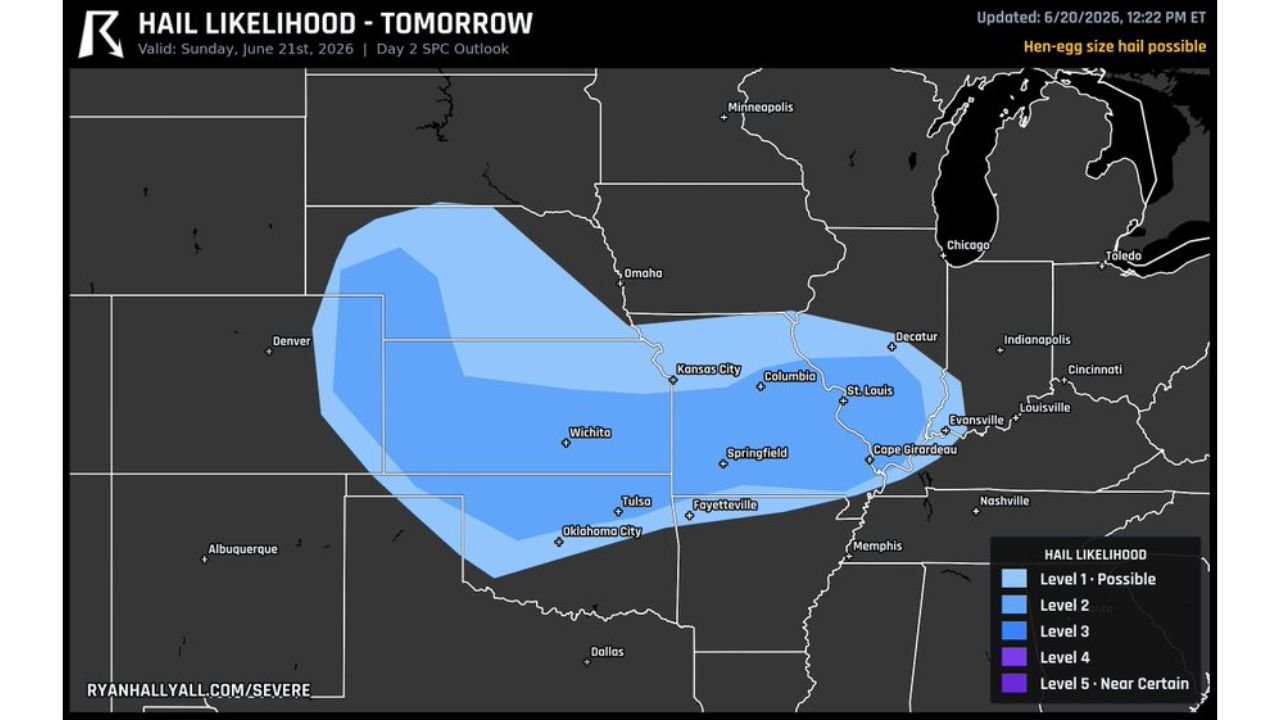
Hail Likelihood Spans From Eastern Colorado to Southern Illinois
According to the outlook map, hail likelihood is broken into five levels, ranging from Level 1 (Possible) to Level 5 (Near Certain). The broader threat area covers cities including Denver, Wichita, Kansas City, Columbia, St. Louis, Springfield, Tulsa, Oklahoma City, Fayetteville, and Cape Girardeau, with the highest concentration of risk centered over the tri-state region near Kansas, Missouri, and Oklahoma.
Residents Urged to Prepare Ahead of Sunday’s Storms
With slow-moving storms capable of producing damaging hail in concentrated areas, residents across the outlined region are advised to monitor local forecasts closely and take precautions, including moving vehicles under cover, ahead of Sunday afternoon.
For more stories like this, visit our website regularly for the latest updates.